The outfitter at Neel Gap looked through our packs and gave us a few pointers. We can scrunch our tents down to about half size. We can cut up our camp towel and get rid of most of it. The outfitter gave us other helpful hints, too. In general we did a good job of packing.
Laura and I also did a pack shakedown to reduce weight. I managed to cut about 2 1/2 lbs and Laura about 1 1/2 lbs. Unfortunately we both added a 1/2 lb each on a bag liner to add a little warmth at night. Our biggest change was to switch our water purification system from a bulky pump filter to Aqua Mira, a chemical water purification treatment. The food we bought to get us to our next stop also added weight but that's a normal part of this deal.
I hung my tent on the patio of the cabin we're renting to dry it out. Um, the rain came and soaked it. It is now hanging inside. Moral: you can't dry your hands with a wet towel!
I got my trail name today. I have a dark pair of sunglasses and I'm kind of tall at 6'1". I reminded someone of Elwood Blue of the Blues Brothers. I am now known as Elwood. I'm on a mission from God. :)
Curtis
Sent from my iPhone

Dad (Curtis) and daughter (Laura) have talked about through-hiking the Appalachian Trail for years. We began the journey on March 27, 2013. Dad is still on the trail. Daughter hiked through GA and racked up over 100 miles.
Sunday, March 31, 2013
Reflections on the Start (Laura)

After four tough days of hiking, we are taking today as a zero day at
Neels Gap, GA. My body has made some progress as I get my "Trail legs"
and I've definitely made some mental progress as well.
On the morning of our first day, I felt like we were booking it. I
felt great. The afternoon of the same day, I felt like I might die.
Ok, maybe I'm exaggerating, but it was rough. Day two was too. I was
tired and cold and sore and missing Eric so much, I was was starting
to wonder if hiking the Trail was the right thing to do. I will not
admit to calling him that night sobbing, so don't ask.
Anyway...day three was by far the worst day for my sore body. I could
hardly stand up at the end of the day. But the night was a little
warmer and I slept well after some good campfire conversation with new
friends.
I felt much better about the Trail after that night. We had a good
hike on day four and got to Neels Gap last night. We rented a cabin
with two new friends, Indian and Greenlite. And Dad has a trail name
now: Elwood. Like, from Blues Brothers. Eric's been trying to get me
to watch that movie for months now. Guess it's time to give in. I,
however, am still waiting for my trail name, but I'll let you know
when I get one.
Tomorrow is a 12-mile day. Our longest so far, but I think we can do
it. I just hope the weather clears up.
Saturday, March 30, 2013
R&R, March 30 (Curtis)
Mile 31.7, Neel Gap
It rained a little last night, a good test for our tents; they passed the test.
Today's hike took us to the top of Blood Mountain. The view up there was fantastic. Blood Mountain is the highest point on the trail in Georgia at 4,461'. We climbed 1,581' in 5 miles to get there. It wasn't as hard of a hike as all the hype we heard leading up to it.
We are currently at Neel Gap where we are staying in a cabin shared with 2 other thru-hikers to cut down on our costs. Laura and I are both sore (mostly our legs but also our backs) so we are taking a down (zero) day tomorrow to recover. After that we plan to pick up the pace a bit. These first couple of weeks are going to be a little slow on purpose in an effort to alleviate any injuries.
Curtis
Sent from my iPhone
Trail Magic, March 29 (Curtis)
Mile 24.3, Lance Creek
We experienced our first trail magic from David and his gang. They staged at Woody Gap with a grill and a cooler full of Gatorade. What a treat! I had a hamburger, a hotdog, and drank down 2 liters of Gatorade. It was soooooooo good! Dave was a hiker and experienced trail magic on his trek and wanted to return the favor. He does it several times during the hiking season. Thanks, Dave!
It was another chilly morning but not as bad as yesterday. It was good to get an early start. We were both very tired by the end of the day but once we got set up for the night we hung out at the campfire and communed with several other thru-hikers. We felt relaxed and had a good time.
Curtis
Sent from my iPhone
Thursday, March 28, 2013
Cold and Beautiful, March 28 (Curtis)
At mile 17.2. A short day but that was purposeful. Tomorrow is another short day then Neal's Gap on Saturday where we plan to take a day of rest and recovery.
This morning was cold, cold, cold! I've never been so cold in my life. After a slow start we climbed a steep mountain then down and up for a while. There were some great views but hard hiking. Then we hit a stretch that was absolutely beautiful. We took a break at Justus Creek...beautiful. We landed at Gooch Gap where will spend the night.
Curtis
Sent from my iPhone
After a couple days of delays, the hiking began in earnest today (Wed.) for Curtis and Laura. I road up the forest service road to Springer Mountain with them once again. It was still COLD and there was snow on the ground, but today the sun finally made an appearance and it cheered us all to finally be rid of the winter weather. We took the necessary photos at the appropriate places and then I watched Curtis and Laura disappear into the woods, after observing their faces. There was a mixture of excitement and apprehension as they donned their packs in the very cold morning air. I headed north to drive back home to West Virginia - - a nine-hour trip. I didn't see another car for miles and miles on the dirt backroad I was on. But I did my best to absorb as many details as possible as I drove down the mountain. I knew I was seeing a little of what hikers were encountering. The road was sometimes lined by huge rocks with two-foot long icicles. The forests were still cloaked in winter brown, with the occasional green of a stubby pine, or the mountain laurel. A lone wood thrush would fly up into the brush, his flute-like song making the woods more magical once spring really arrives. For nine hours I drove through some of the beautiful mountains of the eastern states. I am eager to hear of the finer details of these mountains as Curtis and Laura journey through them over the next several months.
~ Theresa ~


~ Theresa ~


Wednesday, March 27, 2013
Theresa here.
I likely won't have much reason to post normally, unless it's about sending supplies, but since I was involved in the kick-off of Curtis and Laura's adventure, I'll post some photos and a few observations from my few days of involvement in getting them started.
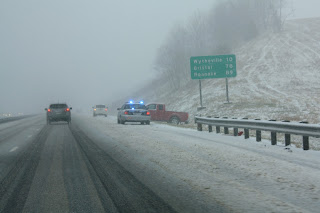
We departed from our home in West Virginia with an anticipated forecast of pretty nice weather for them to start the AT this past Monday, but here are a few photos of what we ran into on our way down to north Georgia. The winter system which we expected to miss, had evolved differently than the forecast had predicted. It slammed square into us. Rain, sleet, snow, fog...pretty much everything but sunshine.


I likely won't have much reason to post normally, unless it's about sending supplies, but since I was involved in the kick-off of Curtis and Laura's adventure, I'll post some photos and a few observations from my few days of involvement in getting them started.
We departed from our home in West Virginia with an anticipated forecast of pretty nice weather for them to start the AT this past Monday, but here are a few photos of what we ran into on our way down to north Georgia. The winter system which we expected to miss, had evolved differently than the forecast had predicted. It slammed square into us. Rain, sleet, snow, fog...pretty much everything but sunshine.


AT Day 1, March 27, 2013
We had a really nice day of hiking today. We made it to mile 10.5 and set up camp. We started out in light snow with snow still on the ground. Hikers we caught up with talked about how cold it was the night before. I'm really glad we postponed our start.
We took a rest at Hawk Mountain shelter where we witnesses the birth of two trail names, Rip and Uke. Rip tore his pants yesterday but it was too cold for him to remove them to sew them. Laura helped with that project. Uke carries a Ukulele. I'm not kidding. He likes to hike at night and play his Ukulele. Really, I'm not kidding. The majority of the hikers are thru-hikers but some are just hiking sections.
My favorite snack? Dried fruit provided by Laura and Eric: apples, strawberries, bananas, pears...yummy!. It packs a burst of flavor in each bite.
Curtis
Sent from my iPhone
Tuesday, March 26, 2013
AT-1 Days (Curtis)
Today was another cold, snowy, and windy day at our staging area in Dahlonega, GA. Tomorrow's forecast shows a cold morning but with abundant sunshine...YAY...and a high of 53. That is good news.
After breakfast, we went into town to check out some antique shops and do a final walkthrough at an outfitters. We found a chocolate store and loaded up with essentials :). We also bought extra baggies to use for storage.
I've got my pack packed, water containers filled, and my clothes laid out. Let the journey begin.
Curtis
Sent from my iPhone
Monday, March 25, 2013
Southern Terminus - Day One (Laura)

of bad weather. Yeah, it wasn't particularly pleasant here in town,
but I wasn't sure at first if it was worth postponing. But so as to
not waste a full day, we headed up to Springer Mountain to get in our
first mile. We drove up a snowy, winding dirt road, and the higher up
we got, the more nervous I became about the 2,180 mile journey ahead.
"Why are we doing this? I can't believe we're doing this. I cannot
believe we're doing this..." And so on. We eventually arrived at a
parking lot I was sure would be empty. It was not. There were about
five other cars in the lot and at least as many people. "These people
are nuts. We're nuts." But we were only there to complete the first
mile today.
The road and parking lot separated the first mile of the trail from
the rest. In order to hike that first mile, we would have to hike to
the top of Springer Mountain—the beginning of the Trail—and back down
to the parking lot where we started. It's too bad we have to backtrack
just to get started.
I thought it might be a little cooler than down in the town, but it
was much colder, maybe by 15 degrees. And it was snowy, windy, and
icy. As we headed up Springer, I began feeling much more comfortable.
Yes, it was still cold and miserable, but I was able to remember why I
decided to do this: I like it! Still, today's day hike was one thing;
spending the night in that weather will be another. I'm glad we
decided to do that mile. It loosened my nerves and got us started on a
great adventure.
AT-2 take 3, Springer Mountain (Curtis)


There are two ways to get to Springer Mountain. One way is what I've described above. That way forces you to drive some winding dirt roads and then have to backtrack a mile of the trail. The other way is to start in Amicalola Falls State Park and hike north to Springer Mountain. That's an 8.8 mile hike just to get to the starting point.
The forecast for tomorrow starts with snow and wind so we've decided to postpone the big trek another day. We now plan to start on Wednesday.
Sunday, March 24, 2013
AT-2 Days...take 2 (Curtis)
We decided to postpone our start by one day due to weather. We drove from West Virginia to Georgia today through some really bad winter weather. I fishtailed next to a semi, which scared the begeebers out of me (and I'm sure it did the same to my two passengers). We saw 7 accidents along the way due to slippery conditions. We started out in rain, then it turned to sleet, then snow, then rain, the sleet mixed with snow, then heavy snow with snowflakes as big as birds. Once we reached North Carolina, the sun came out, then it turned back to rain all the way to Georgia. The weather is supposed to be rainy and windy tomorrow then windy tomorrow night. So, we'll stay in our hotel room for another day to wait this thing out. That will also give the weather a chance to improve for Theresa's trip back to West Virginia.
Saturday, March 23, 2013
Almost Gone (Laura)
I'm not going to lie, I'm getting pretty nervous about starting our big adventure. My food—for four days—weighed in at 9 lbs, so I imagine that my entire pack weight, including food and water, will be around 35 lbs. I would have really liked to keep the weight under 30 lbs, but maybe it will be when I shed my winter gear in a few weeks. And, as Eric said, the food may weigh 9 lbs now, but it won't in four days. Still, I keep wondering if there's anything I could leave behind.
We leave for Georgia in the morning and will get on the Trail first thing Monday. There will be places along the way to mail home the things I can live without—and I'm looking forward to finding out what they are.
We leave for Georgia in the morning and will get on the Trail first thing Monday. There will be places along the way to mail home the things I can live without—and I'm looking forward to finding out what they are.
AT-2 Days (Curtis)
Theresa threw Laura and me a send-off party at our house. Nearly our entire neighborhood came. Before you think that's a huge group, let me explain our neighborhood. It basically consists of the people who live on our road. The number of families that lives on our road is about 10. They are great neighbors and we are lucky to live here. The weather was nice. We cooked out on our grill: burgers, dogs, and brats. The neighbors brought sides and desserts. It was great fun.
Laura and I packed our food for the first 4 days. My food weighed about 7.5lbs. Ugh! Laura's weighed about 9lbs. I guess that girl eats good. :) I shouldn't talk about how much girls eat, just like one never asks a girl how much she weighs or how old she is. (Geez, girls are high maintenance.)
To cut back on some weight, I cut off excess strapping from my pack. As I began to cut, I fantasized of losing 5lbs off my pack. In the end, I lost only about 0.5lb. I guess every little bit helps. I hear that hikers start shedding things soon after they start the trail. I'm anxious to see what kind of things I will be culling from my pack.
Friday, March 22, 2013
Track Us (Curtis)
Note the new tab on this blog at the top titled "Track us". It takes you directly to a SPOT website. Once we are on the move, you can track our location.
SPOT is a GPS tracker which also has a button on it to send for help. It has other buttons to send simple messages back home or to friends like, "I'm OK, just checking in." It's a pretty cool tool for those who hang out in the wild.
http://www.findmespot.com/en/
SPOT is a GPS tracker which also has a button on it to send for help. It has other buttons to send simple messages back home or to friends like, "I'm OK, just checking in." It's a pretty cool tool for those who hang out in the wild.
http://www.findmespot.com/en/
AT-3 Days (Curtis)
I finished a few more chores around the house including installing the last gate on our fence. Yay, the fence is finally complete! Now, doggy won't be wandering all over the farm or onto the road which is about 1/4 mile from the house.
Then we (Laura and I) got to the important task of organizing all of our stuff. I tried really hard to cull the unimportant things. However, my pack still weighed 30lbs without food and water. It did include ALL of my clothes so I guess I could subtract that from the total. My pack alone weighs 7lbs empty...ugh! I should probably replace it but it's practically brand new and I don't want to spend the money on a new one at this point. Laura's pack weighed in at about 20lbs (without the clothes she will be wearing). Where have I gone wrong!!!???

Can you guess which pack is Curtis's and which one is Laura's? It looks like a girly-bear pack and a daddy-bear pack. :)
Curtis
Then we (Laura and I) got to the important task of organizing all of our stuff. I tried really hard to cull the unimportant things. However, my pack still weighed 30lbs without food and water. It did include ALL of my clothes so I guess I could subtract that from the total. My pack alone weighs 7lbs empty...ugh! I should probably replace it but it's practically brand new and I don't want to spend the money on a new one at this point. Laura's pack weighed in at about 20lbs (without the clothes she will be wearing). Where have I gone wrong!!!???
Can you guess which pack is Curtis's and which one is Laura's? It looks like a girly-bear pack and a daddy-bear pack. :)
Curtis
Thursday, March 21, 2013
AT-4 Days
I received my final package from REI today...just in time. I ordered an air mattress, a trowel, a platypus water bottle, and a solar charger for our iPhones.
We also reviewed the AT Data Book to see where the Post Offices and grocery stores are. It looks like we will have no choice but to get off the trail on a regular basis to get food. I suppose we will either hike or hitchhike to these important locations. Any advice from past through-hikers would be appreciated.
We also reviewed the AT Data Book to see where the Post Offices and grocery stores are. It looks like we will have no choice but to get off the trail on a regular basis to get food. I suppose we will either hike or hitchhike to these important locations. Any advice from past through-hikers would be appreciated.
Trail Ring
Dad said I'm in charge of posting "girly stuff" to the blog. So, here it goes. In December, my favorite person in the whole world asked me to marry him! With our wedding scheduled for October and my hiking the trail for several months, I won't see him but a couple times before our wedding day. Neither of us much liked the idea of me hiking with my ring, and liked even less the idea of me hiking with no ring. So, he found me a Trail ring.
.JPG) We wanted to find something simple and pretty. We took our time trying to find one that seemed right. We found it in the etsy.com shop OddsAndEndsByKaley (http://www.etsy.com/shop/OddsAndEndsByKaley). Kaley made it just for me and it is beautiful. It is sterling silver with a labradorite stone. I'm still very sad to leave my engagement ring behind, but happy to have a pretty stand-in.
We wanted to find something simple and pretty. We took our time trying to find one that seemed right. We found it in the etsy.com shop OddsAndEndsByKaley (http://www.etsy.com/shop/OddsAndEndsByKaley). Kaley made it just for me and it is beautiful. It is sterling silver with a labradorite stone. I'm still very sad to leave my engagement ring behind, but happy to have a pretty stand-in.
.JPG)
Wednesday, March 20, 2013
AT-5 Days
We looked at the weather forecast for the beginning of our trek. It looks like we are going to get lucky with this next storm system. The storm goes through our start point (Springer Mountain, Georgia) on Sunday and clears out for our start on Monday. The weather forecast shows highs in the mid 50s to low 60s and lows near freezing to low 40s. That sounds like great hiking and camping weather to me!
Laura has been feeling a bit under the weather. This morning she woke up with gunk in her lungs. We need to get her better before we start the trail. She better not pass it on to me!
Other than that, I've just been taking care of a few little things. I met with the social director at the Greenbrier Resort. I will be giving their Memorial Day speech which means I'll be coming off the trail for a few days at the end of May. I FINALLY took all of our moving boxes to the recycle center. It's amazing how much room they were taking up.
Tomorrow is a bad-weather day so indoor activities for me on AT-4.
Curtis
Tuesday, March 19, 2013
AT-6 Days

For those of you who want to help with food, click on the "Food" tab at the top of this page.
I'm also doing some last minute things around the house before I depart. I recently built a fence to keep the dog from wandering too far from the farm and getting hit by a car or picked up and taken to another home. Today, I cut the boards for the fourth and final gate for the fence. Once Theresa puts two coats of stain on it and it dries, I'll put it together and hang it. The fence will finally be done. I also installed a porch light on the front porch. The previous one did not match our log home.
Remember our wounded warriors. Please help us reach our goal of raising $10,000 for the Wounded Warrior Project. Click the WWP Fundraiser at the top if this page.
Monday, March 18, 2013
AT-7 Days
Seven days until Laura and I begin the Appalachian Trail.
Today, I picked up Laura in Boone, NC. She returned from Mexico on Saturday where she was on a mission trip. We had about 3 1/2 hours of car time to talk about some of our plans.
We talked about this blog. I want to post about what we will be doing in preparation for our journey for the next 7 days. Did you know that Google's Blogger gives you the option of updating this blog via email? That is so cool! We can simply send an email and our blog is magically updated. We don't have to log in to our account, click on "Post", and type on a website. Emailing our blog posts will be so easy and convenient.
I'm waiting on REI to send out our dividends. Once I'm able to use my dividends (which will be significant this year because I bought a bunch of stuff last year for Teller County Search and Rescue), I plan to spend them on things I need for the trail.
- I've decided to go with a 3 1/2" air mattress as opposed to the 1 1/2" I now have. My back has taken a beating over the years so I will sacrifice carrying a half pound more weight to sleep a little more comfortably at night.
- I'm also going to try a solar charger so I can charge my iPhone while I hike. My iPhone will be the tool I use to update this blog and there are no outlets in the woods for me to plug in to.
- Additionally, I'm going to carry a Platypus Soft Water Bottle to use around camp.
Cold weather clothing. I'm going to try to stay light but that could be a trick with the potential for cold weather. What I've decided to go with is:
- Running tights for underneath my pants.
- Water resistant convertible pants (the lower legs zips off to make shorts).
- Polyester/spandex short sleeve T-shirt
- Polyester/spandex long sleeve T-shirt
- Insulated polyester/spandex long sleeve T-shirt
- Micro-fleece pullover.
- A pair of glove-mittens.
- A micro-fleece beanie cap.
- Nike Air Pegasus Trail Running Shoes (I waterproofed them; we'll see how that works out).
We'll come off the trail in late April and again in late May. As we move North, Theresa will pick us up as we enter Virgina (late April) and then again as we enter Shenandoah National Park (late May). From then on, we'll be on our own except for the possibility of my sister picking us up in New York when we get up there.
Food still has us a little baffled. We'll have Theresa send us food to certain Post Offices along the way. Unfortunately, some of the Post Offices listed in the Appalachian Trail Data Book are over 10 miles off the trail. I'm not really interested in hiking or hitching that far to pick up a package. Some of you have expressed an interest in helping with food during our trek. Go to our blog page for more information on helping us out: http://daddaughterapptrail.blogspot.com/p/food.html.
I filled Laura in on the Wounded Warrior Project. Our goal is to raise $10,000, so please spread the word. We have already had people make donations; that's AWESOME! Go to https://support.woundedwarriorproject.org/individual-fundraising/daddaughterapptrail.blogspot.com/ and make a donation. Any amount will be very helpful...THANK YOU!
Curtis
Wednesday, March 13, 2013
Through-hiking the Appalachian Trail
Hello Everyone,
Laura and I are about to begin our grand adventure of through-hiking the Appalachian Trail from foot to head, Georgia to Maine, South to North, a 2,185 mile trek through some of the most beautiful country in the world. As the time gets closer, our anxiety increases and so does our excitement. Sleep and food are my biggest concerns, followed by unforeseen injuries (not to mention other aches and pains). Our goal is to finish the trail by the end of August, giving us about 6 weeks at home to complete the planning for Laura's October wedding. That date puts us at an average of about 13.7 miles per day, every day, from March 25th to August 31st. We do plan to take some "zero" days, both at our home in West Virginia and on the trail. So on hiking days, we will have to average close to 15 miles per day. You can follow our progress at: daddaughterapptrail.blogspot.com.
1. Fundraiser. I am a proud sponsor of the Wounded Warrior Project (http://www.woundedwarriorproject.org/). Their mission is "To honor and empower wounded warriors." I figured that since I will be hiking so hard for so long, I would put my effort into raising money for this organization that I feel very strongly about. Laura feels the same way. Please join us in participating in this fundraiser. Giving just 1 cent per mile will raise $21.85. Can you do that? What about 2 cents per mile, or 3 or 5 or 10? Or if you prefer, you can pledge a flat amount, say $10 or $20 or $50 or $100. This donation will go straight to the Wounded Warrior Project. You can make your donation at: https://support.woundedwarriorproject.org/individual-fundraising/daddaughterapptrail.blogspot.com/. You can donate now or wait until we complete the journey.
2. Several people have asked about sending food or packages to us as we hike. After deploying three times and being away from home for nearly 2.5 years, it definitely feels really special to get packages in the mail. Food donations would be good morale boosters for Laura and me. Here are two options:
a. Send food! Gee, what a novel idea! But that is not as easy as it sounds. Post Offices are located along the route, but some of them are a days hike or so to get to. And, they are spread out far enough that we would have to carry weeks' worth of food between Post Offices if we relied on that source alone. Therefore, Theresa (that's my wife, for those who don't know) will be the clearing house and food hub for this trek. If you want to send trail food, send it to her. She will box up a care package and send it to the appropriate Post Office along the way. Otherwise we would run the risk of receiving several packages at one Post Office (too much to carry) and none at another (I feel the hunger pains already). See a suggested list of food at the end of this message.
OR
b. Send gift cards that Laura and I can use at grocery stores along the way. Grocery stores are more prevalent along the trail than Post Offices. Gift cards would give us the flexibility to buy what we need and want along the way, and less weight to carry in our packs. You can pick up a pre-paid Visa or Mastercard at many department and convenient stores. Any amount would be very much appreciated. These could be sent to Theresa, too, and she can forward them to us in the care packages along with the other food she will be sending.
Thanks for any help you may provide. Donations to the Wounded Warrior Project take priority over our food needs.
Laura and I will be updating the blog (http://daddaughterapptrail.blogspot.com/) as much as possible. I look forward to this adventure and I hope you enjoy following us from Springer Mountain to Mount Katahdin.
Curtis
-------
Food List
Oatmeal
Pop tarts
Coffee singles
Hot chocolate packs
Peanut butter
Jelly packets
Squeeze margarine
Chocolate
Cookies
Trail mix
Crackers and cheese
Crackers and peanut butter
Peanut M&Ms (dark and milk chocolate)
Nuts roasted in oil
Raw almonds
Dried fruits
Beef sticks
Tuna (flat individual packets)
Spam (flat individual packets)
Beanie weenie mini cans
Sardines (flat pop top cans)
Salmon flat packs
Deviled ham (like potted meat)
Chicken flat packs
Precooked/prepackaged hamburger
Ravioli mini cans
Spaghetti & meat ball mini cans
Chicken N Dumpling mini cans
Easy-Mac and cheese
Pita bread
Hamburger helper
White rice (the boil packs)
Nutty bars
Oatmeal cream pies
Fudge rounds (yummy, my favorite!)
Raisins
Candy bars
Small tortilla wraps
Small coffee creamer canister
Sugar packets
Herbal teas
Ramen noodles
Snack pack puddings
Pistachio nuts
Salt & pepper packets
Mashed potatoes- Idahoan individual packs
Red beans and rice packs
Granola bars
Flavored drink mixes
Gatorade mix (individual packets)
Cheese sticks
Kudos
Lipton pasta and sauce
Subscribe to:
Comments (Atom)